-
Collins Children’s World Map
Collins UK
Map (Collins, July 1, 2019)This highly illustrated pictorial map is designed to take children on a journey of discovery around the countries of the world. The mapping is clear, colorful and highly informative and shows countries and capital cities. Stunning illustrations are used to depict themes such as national emblems, customs, food, birds, animals, buildings and sports to help younger readers gain an understanding of peoples around the world. K
K
-
Collins Children’s World Map
Collins UK
Poster (Collins, July 1, 2015)This highly illustrated pictorial map is designed to take children on a journey of discovery around the countries of the world. The mapping is clear, colorful, and highly informative, and shows countries and capital cities. Stunning illustrations are used to depict themes such as national emblems, customs, food, birds, animals, buildings, and sports to help younger readers gain an understanding of peoples around the world.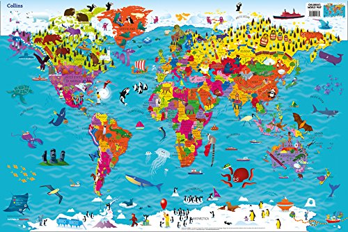 K
K
-
Collins Children's World Map
these sellers
Map (Collins, April 29, 2010)Colourful Illustrated Map of the World A beautifully illustrated map of the world, designed to take children on an exciting journey around the countries of the world. Stunning illustrations are used with a clear colourful world political map to depict customs, animals, buildings, sport, landmarks etc., to help younger readers gain an understanding of peoples and places around the world. Facts are included about each continent to give children an insight into the way of life of people in far away lands.
-
Children's World Map
Akros
Map (Akros, July 1, 2008)This CHILDREN'S WORLD MAP for kids who you are trying to teach them about the world. A colorful, educational world map which will keep your kids entertained for hours. The children's world map was specially produced for kids, and provides a great way for you to spend time with your kids and educate them, while all the time having fun! In this increasingly connected world, it's important to give your kids an understanding of different countries and cultures. The map offers a wealth of information. It shows more geographical features including: international borders, flags, countries, major cities, seas and oceans, mountain ranges, major rivers. More than 300 of illustrations and descriptions on the world map show: animals throughout the world and indicates the areas where they live, explorers, historical items, cultural items, ships and sailboats, legend of icons. Size: 27.5x39 inches, Rolled Laminated with Polypropylene film (Standard thermal laminating film). You can write with dry erase marker or water-based pen above it and wash it easy.
-
Collins Children's World Wall Laminated Map
Steve Evans
Map (Collins, July 12, 2018)Laminated Illustrated Map of the World This highly illustrated pictorial map with a gloss finish is designed to take children on a journey of discovery around the countries of the world. The mapping is clear, colourful and highly informative and shows countries and capital cities. Stunning illustrations are used to depict themes such as national emblems, customs, food, birds, animals, buildings and sports to help younger readers gain an understanding of peoples around the world. Dimensions 610 X 915 mm Illustrated by Steve Evans.
-
Collins Children's World Atlas
Collins UK
Hardcover (Collins Geo, April 1, 2014)An ideal family reference presenting a view of the world's people and places in one compact, easy-to-read atlasThrough authoritative maps, eye-catching illustrations, and up-to-date geographical information, this reference brings to life every continent and sub-region of the world. Great care has been taken to bring maps and statistics to life in a format that is relevant for the 21st century. With dramatic imagery and the creative use of graphics, key information is presented in a lively and engaging way that will not only answer questions but stimulate further inquiry and expand knowledge. Each page presents detailed but easily understandable analyses of social, geographic, economic, and environmental trends across the regions. Fact-packed descriptions focus on the key social, cultural, historical, and physical features of individual countries and cities. A scholarly level of detail and research is presented in an appealing and accessible format, making for a book that is a pleasure to browse as well as to learn from. T
T
-
Ancient World Children's Map
None
Map (GeoCenter International Ltd, )None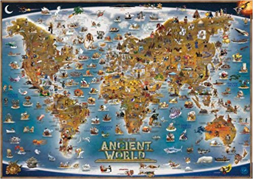
-
Collins World Wall Map
HarperCollins
Paperback (Harpercollins Pub Ltd, March 4, 2010)None
-
World's children
Mortimer Menpes
Hardcover (A. & C. Black, March 15, 1903)World's Children
-
World's Children
Mortimer Menpes, Dorothy Menpes
Hardcover (Arkose Press, Oct. 19, 2015)This work has been selected by scholars as being culturally important, and is part of the knowledge base of civilization as we know it. This work was reproduced from the original artifact, and remains as true to the original work as possible. Therefore, you will see the original copyright references, library stamps (as most of these works have been housed in our most important libraries around the world), and other notations in the work.This work is in the public domain in the United States of America, and possibly other nations. Within the United States, you may freely copy and distribute this work, as no entity (individual or corporate) has a copyright on the body of the work.As a reproduction of a historical artifact, this work may contain missing or blurred pages, poor pictures, errant marks, etc. Scholars believe, and we concur, that this work is important enough to be preserved, reproduced, and made generally available to the public. We appreciate your support of the preservation process, and thank you for being an important part of keeping this knowledge alive and relevant.
-
World's Children
Mortimer Menpes, Dorothy Menpes
Paperback (Nabu Press, April 15, 2012)This is a reproduction of a book published before 1923. This book may have occasional imperfections such as missing or blurred pages, poor pictures, errant marks, etc. that were either part of the original artifact, or were introduced by the scanning process. We believe this work is culturally important, and despite the imperfections, have elected to bring it back into print as part of our continuing commitment to the preservation of printed works worldwide. We appreciate your understanding of the imperfections in the preservation process, and hope you enjoy this valuable book. ++++ The below data was compiled from various identification fields in the bibliographic record of this title. This data is provided as an additional tool in helping to ensure edition identification: ++++ <title> World's Children<authors> Mortimer Menpes, Dorothy Menpes<publisher> A. & C. Black, 1903<subjects> Children; Children in art; Children's clothing; Children's costumes
-
World's children,
Mortimer Menpes
Hardcover (A. & C. Black, March 15, 1904)None